Wachtwoord kwijt? Nieuwe gebruiker? Registeren
Clownfish, Philippines. Photo by Stephane Rochon.
Enjoy and contribute!
| Zoek de beste duiklocaties |
|
|
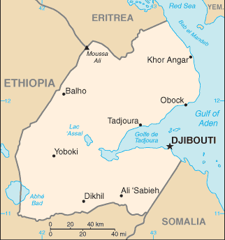
 Djibouti
Afrika
Les 7 frères (Seven brothers) are a fantastic area for scuba. Whale sharks are often encountered.
Locatie: Eastern Africa, bordering the Gulf of Aden and the Red Sea, between Eritrea and Somalia
Geografische coordinaten: 11° 30' N, 43° 0' E
Kustlijn km: 314 km km
Klimaat: desert; torrid, dry
Terrein: coastal plain and plateau separated by central mountains
Hoogte: lowest point: Lac Assal -155 m
highest point: Moussa Ali 2,028 m
Natuurlijke gevaren: earthquakes; droughts; occasional cyclonic disturbances from the Indian Ocean bring heavy rains and flash floods
Valuta: Djiboutian franc (DJF)
Populatie: 496,374 (July 2007 est.)
Talen: French (official), Arabic (official), Somali, Afar
Hoofdstad: Djibouti
Provincies: 6 districts: Ali Sabieh, Arta, Dikhil, Djibouti, Obock, Tadjourah
Meer details
| Jan | Feb | Mar | Apr | May | Jun | Jul | Aug | Sep | Oct | Nov | Dec | |
|---|---|---|---|---|---|---|---|---|---|---|---|---|
| Climate | ||||||||||||
| Air temp. | ||||||||||||
| Water temp. | ||||||||||||
| Equipment | Don't know | Don't know | Don't know | Don't know | Don't know | Don't know | Don't know | Don't know | Don't know | Don't know | Don't know | Don't know |
| Best season | ||||||||||||
Extra kaart
Wil je info toevoegen over Djibouti? Laat ons weten...
Dit is een interactieve kaart! Gebruik "controls" voor pan and zoom op deze kaart.
- Favoriet
-
Je favoriete and toekomst duiklocatie lijst
Je favoriete zone staat niet in het overzicht? Zone toevoegen
Zones
| Zones (3) | Duiklocatie | Sub zones |
|---|---|---|
| 7 Brothers Islands | 4 | 0 |
| Moucha Islands | 4 | 0 |
| Tadjourah Gulf | 8 | 0 |
Duiklocatie
| Duiklocatie (1) | Kwaliteit | Gem diepte | Max diepte | Ervaring | Duik type | ||
|---|---|---|---|---|---|---|---|
| Djibouti harbour | - / - | 3 m | 6.1 m | Alle duikers | 

|

 Duiklogs
Comments
Wees de eerste en becommentarieer dit land
Fouten, Feedback
Als je nieuwe informatie wilt toevoegen of fouten van dit land wilt herstellen, Stuur ons feedback.
Adverteer
Wannadive.net 24/24
Wannadive.net op jouw mobiel
![]()
RSS Alle RSS feeds van Wannadive.net
Nieuwsbrief Alle nieuws per E-mail