Lost password? New user? Register
Lizard fish, Philippines. Photo by Stephane Rochon.
Enjoy and contribute!
| Find the best dive sites |
|
|
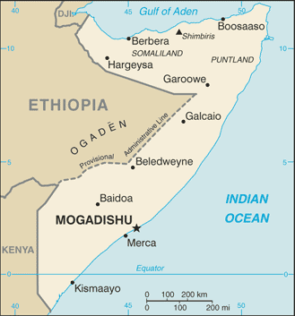
 Somalia
Africa
It is NOT recommanded to organize a dive trip in Somalia now. A civil war started in 2006 and it is dangerous to go there for now.
Location: Eastern Africa, bordering the Gulf of Aden and the Indian Ocean, east of Ethiopia
Geographic coordinates: 10° 0' N, 49° 0' E
Coastline km: 3,025 km km
Climate: principally desert; northeast monsoon (December to February), moderate temperatures in north and very hot in south; southwest monsoon (May to October), torrid in the north and hot in the south, irregular rainfall, hot and humid periods (tangambili) between monsoons
Terrain: mostly flat to undulating plateau rising to hills in north
Elevation: lowest point: Indian Ocean 0 m
highest point: Shimbiris 2,416 m
Natural hazards: recurring droughts; frequent dust storms over eastern plains in summer; floods during rainy season
Currency: Somali shilling (SOS)
Population: 8,863,338 (July 2006 est.)
Languages: Somali (official), Arabic, Italian, English
Capital: Mogadishu
Divisions: 18 regions: Awdal, Bakool, Banaadir, Bari, Bay, Galguduud, Gedo, Hiiraan, Jubbada Dhexe, Jubbada Hoose, Mudug, Nugaal, Sanaag, Shabeellaha Dhexe, Shabeellaha Hoose, Sool, Togdheer, Woqooyi Galbeed
More details
| Jan | Feb | Mar | Apr | May | Jun | Jul | Aug | Sep | Oct | Nov | Dec | |
|---|---|---|---|---|---|---|---|---|---|---|---|---|
| Climate | ||||||||||||
| Air temp. | ||||||||||||
| Water temp. | ||||||||||||
| Equipment | ||||||||||||
| Best season | ||||||||||||
Additional map
Wanna add some info about Somalia? Let us know...
This is an interactive map! Use controls to pan and zoom this map.

- Favourite
-
Your favourites and future dive site lists
Your favorite zone isn't listed ? Add a zone
Zones
| Zones (1) | Dive sites | Sub zones |
|---|---|---|
| Bajuni Islands | 1 | 0 |
 Comments
Be the first to comment this country
Errors, Feedback
If you want to add new information or you have found errors on this country, Send us feedback.
Advertise
Wannadive.net 24/24
Wannadive.net on your mobile
![]()
RSS All the RSS feeds of Wannadive.net
Newsletter All news by email