Mot de passe perdu ?
Nouvel utilisateur ? Créer un compte
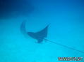
Big eye, Philippines. Photo by Stephane Rochon.
Appréciez et contribuez !
| Trouvez les meilleurs sites |
|
|
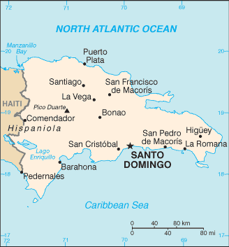
 Dominican Republic
Amérique centrale
Famous dive area near Santo Domingo is "La Caleta", an underwater national park with wrecks such as the "The Hickory" wreck, "El Limon" wreck...
Localisation: Caribbean, eastern two-thirds of the island of Hispaniola, between the Caribbean Sea and the North Atlantic Ocean, east of Haiti
Coordonnées géographiques: 19° 0' N, 70° 40' W
Côte: 1,288 km km
Climat: tropical maritime; little seasonal temperature variation; seasonal variation in rainfall
Relief: rugged highlands and mountains with fertile valleys interspersed
Sommets: lowest point: Lago Enriquillo -46 m
highest point: Pico Duarte 3,175 m
Risques naturels: lies in the middle of the hurricane belt and subject to severe storms from June to October; occasional flooding; periodic droughts
Monnaie: Dominican peso (DOP)
Population: 9,183,984 (July 2006 est.)
Langues: Spanish
Capitale: Santo Domingo
Découpage administratif: 31 provinces (provincias, singular - provincia) and 1 district* (distrito); Azua, Baoruco, Barahona, Dajabon, Distrito Nacional*, Duarte, El Seibo, Elias Pina, Espaillat, Hato Mayor, Independencia, La Altagracia, La Romana, La Vega, Maria Trinidad Sanchez, Monsenor Nouel, Monte Cristi, Monte Plata, Pedernales, Peravia, Puerto Plata, Salcedo, Samana, San Cristobal, San Jose de Ocoa, San Juan, San Pedro de Macoris, Sanchez Ramirez, Santiago, Santiago Rodriguez, Santo Domingo, Valverde
Plus d'informations
| Jan | Feb | Mar | Apr | May | Jun | Jul | Aug | Sep | Oct | Nov | Dec | |
|---|---|---|---|---|---|---|---|---|---|---|---|---|
| Climate | ||||||||||||
| Air temp. | ||||||||||||
| Water temp. | ||||||||||||
| Equipment | Keine Ahnung | Keine Ahnung | Keine Ahnung | Keine Ahnung | Keine Ahnung | Keine Ahnung | Keine Ahnung | Keine Ahnung | Keine Ahnung | Keine Ahnung | Keine Ahnung | Keine Ahnung |
| Best season | ||||||||||||
Carte
Vous voulez ajouter des informations sur Dominican Republic? Dites-le nous...
Cette carte est interactive ! Utilisez les boutons pour zoomer ou vous déplacer.
- Favoris
-
Vos sites favoris et futures listes de sites
Votre zone préféré n'est pas présente ? Ajouter une zone
zones
| zones (5) | Sites de plongée | Sous-zones |
|---|---|---|
| Boca Chica | 2 | 0 |
| Juan Dolio | 6 | 0 |
| La Romana and Saona Island | 12 | 0 |
| Puerto Plata area | 17 | 0 |
| Punta Cana | 13 | 0 |
Sites de plongée
| Sites de plongée (5) | Qualité | Prof moy | Prof max | Expérience | Type de plongée | ||
|---|---|---|---|---|---|---|---|
| Aquario Reef | 2 / - | 49.2 ft | 52.5 ft | Tous niveaux | 
|
||
| Coral Garden (Luperon) | - / - | 59.1 ft | 82 ft | CMAS ** / AOW | 

|
||
| Cuevas de Du-du | 9 / 1 | 32.8 ft | 42.7 ft | CMAS ** / AOW | 
|
||
| El Derrumbao | 4 / - | 98.4 ft | 121.4 ft | CMAS ** / AOW | 
|
||
| Patricia Wreck | 3 / - | 49.2 ft | 59.1 ft | CMAS * / OW |
|
 Photos
Aquario Reef |

Parque Nacional La Caleta |

Parque Nacional La Caleta |

Parque Nacional La Caleta |

Dernières plongée
|
Derniers voyages
|
Commentaires
Erreurs, Réactions
Si vous voulez ajouter de nouvelles informations ou si vous avez trouvé des erreurs sur cette page, Dite-le nous.
Annonceurs
Wannadive.net 24/24
Wannadive.net sur votre portable
![]()
RSS Tous les flux RSS de Wannadive.net
Newsletter Toutes les nouveautés par courriel