Enjoy and contribute!
| Find the best dive sites |
|
|
 Honduras
Central America
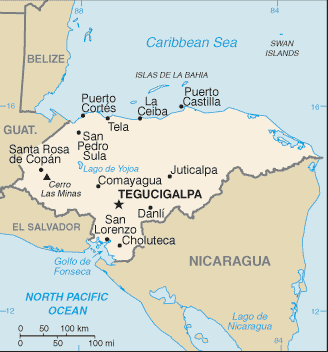
Location: Central America, bordering the Caribbean Sea, between Guatemala and Nicaragua and bordering the Gulf of Fonseca (North Pacific Ocean), between El Salvador and Nicaragua
Geographic coordinates: 15° 0' N, 86° 30' W
Coastline km: 820 km km
Climate: subtropical in lowlands, temperate in mountains
Terrain: mostly mountains in interior, narrow coastal plains
Elevation: lowest point: Caribbean Sea 0 m
highest point: Cerro Las Minas 2,870 m
Natural hazards: frequent, but generally mild, earthquakes; extremely susceptible to damaging hurricanes and floods along the Caribbean coast
Currency: lempira (HNL)
Population: 7,326,496
Languages: Spanish, Amerindian dialects
Capital: Tegucigalpa
Divisions: 18 departments: Atlantida, Choluteca, Colon, Comayagua, Copan, Cortes, El Paraiso, Francisco Morazan, Gracias a Dios, Intibuca, Islas de la Bahia, La Paz, Lempira, Ocotepeque, Olancho, Santa Barbara, Valle, Yoro
More details
| Jan | Feb | Mar | Apr | May | Jun | Jul | Aug | Sep | Oct | Nov | Dec | |
|---|---|---|---|---|---|---|---|---|---|---|---|---|
| Climate | ||||||||||||
| Air temp. | ||||||||||||
| Water temp. | ||||||||||||
| Equipment | ||||||||||||
| Best season | 
|

|

|

|

|

|

|

|

|

|

|

|
Additional map

Wanna add some info about Honduras? Let us know...
This is an interactive map! Use controls to pan and zoom this map.
- Favourite
-
Your favourites and future dive site lists
Your favorite zone isn't listed ? Add a zone
Zones
| Zones (1) | Dive sites | Sub zones |
|---|---|---|
| Bay Islands | 78 | 4 |
 Dive logs
|
 Dive trips
|
 Comments
Errors, Feedback
If you want to add new information or you have found errors on this country, Send us feedback.
Advertise
Wannadive.net 24/24
Wannadive.net on your mobile
RSS All the RSS feeds of Wannadive.net
Newsletter All news by email


