Enjoy and contribute!
| Find the best dive sites |
|
|
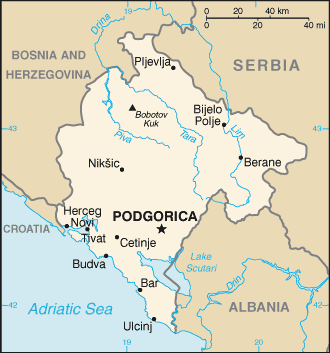
 Montenegro
Europe
Location: Southeastern Europe, between the Adriatic Sea and Serbia
Geographic coordinates: 42° 18' N, 19° 10.8' E
Coastline km: 293.5 km km
Climate: Mediterranean climate, hot dry summers and autumns and relatively cold winters with heavy snowfalls inland
Terrain: highly indented coastline with narrow coastal plain backed by rugged high limestone mountains and plateaus
Elevation: lowest point: Adriatic Sea 0 m
highest point: Bobotov Kuk 2,522 m
Natural hazards: destructive earthquakes
Currency: euro (EUR)
Population: 684,736 (July 2007 est.)
Languages: Serbian, Bosnian, Albanian, Croatian
Capital: Podgorica
Divisions: 21 municipalities: Andrijevica, Bar, Berane, Bijelo Polje, Budva, Cetinje, Danilovgrad, Herceg Novi, Kolasin, Kotor, Mojkovac, Niksic, Plav, Pluzine, Pljevlja, Podgorica, Rozaje, Savnik, Tivat, Ulcinj, Zabljak
More details
| Jan | Feb | Mar | Apr | May | Jun | Jul | Aug | Sep | Oct | Nov | Dec | |
|---|---|---|---|---|---|---|---|---|---|---|---|---|
| Climate | ||||||||||||
| Air temp. | ||||||||||||
| Water temp. | ||||||||||||
| Equipment | ||||||||||||
| Best season | 
|

|

|

|

|

|

|

|

|

|

|

|
Additional map

Wanna add some info about Montenegro? Let us know...
This is an interactive map! Use controls to pan and zoom this map.
- Favourite
-
Your favourites and future dive site lists
Your favorite zone isn't listed ? Add a zone
Zones
| Zones (3) | Dive sites | Sub zones |
|---|---|---|
| Budva | 2 | 0 |
| Kotor | 4 | 0 |
| Petrovac | 1 | 0 |
 Comments
Be the first to comment this country
Errors, Feedback
If you want to add new information or you have found errors on this country, Send us feedback.
Advertise
Wannadive.net 24/24
Wannadive.net on your mobile
RSS All the RSS feeds of Wannadive.net
Newsletter All news by email


