This is an interactive map! Use controls to pan and zoom this map.
Access
|
English (Translate this text in English): NW of Copton Penninsula, between White beach and Copton Point. There are eroded pillars of rock on the surface.
English (Translate this text in English): NW of Copton Penninsula, between White beach and Copton Point. There are eroded pillars of rock on the surface.
NW of Copton Penninsula, between White beach and Copton Point. There are eroded pillars of rock on the surface.
English (Translate this text in English): NW of Copton Penninsula, between White beach and Copton Point. There are eroded pillars of rock on the surface.
English (Translate this text in English): NW of Copton Penninsula, between White beach and Copton Point. There are eroded pillars of rock on the surface.
English (Translate this text in English): NW of Copton Penninsula, between White beach and Copton Point. There are eroded pillars of rock on the surface.
English (Translate this text in English): NW of Copton Penninsula, between White beach and Copton Point. There are eroded pillars of rock on the surface.
English (Translate this text in English): NW of Copton Penninsula, between White beach and Copton Point. There are eroded pillars of rock on the surface.
English (Translate this text in English): NW of Copton Penninsula, between White beach and Copton Point. There are eroded pillars of rock on the surface.
How? By boat
Distance Good boat time (< 30min)
Easy to find? Easy to find
|
|
Dive site Characteristics
Alternative name Umbrella Point, Wreck Point
Average depth 15.0 m / 49.2 ft
Max depth 25.0 m / 82 ft
Current Medium ( 1-2 knots)
Visibility Good ( 10 - 30 m)
Quality
Dive site quality Standard
Experience All divers
Bio interest Poor
More details
Week crowd
Week-end crowd
Dive type
- Wreck
- Reef
Dive site activities
- Orientation
- Photography
Dangers
Additional Information
English (Translate this text in English): Lancair, postal delivery plane, 1993.
Observed in 1998. Nice second dive.
English (Translate this text in English): Lancair, postal delivery plane, 1993.
Observed in 1998. Nice second dive.
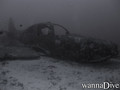
Lancair, postal delivery plane, 1993.
Observed in 1998. Nice second dive.
English (Translate this text in English): Lancair, postal delivery plane, 1993.
Observed in 1998. Nice second dive.
English (Translate this text in English): Lancair, postal delivery plane, 1993.
Observed in 1998. Nice second dive.
English (Translate this text in English): Lancair, postal delivery plane, 1993.
Observed in 1998. Nice second dive.
English (Translate this text in English): Lancair, postal delivery plane, 1993.
Observed in 1998. Nice second dive.
English (Translate this text in English): Lancair, postal delivery plane, 1993.
Observed in 1998. Nice second dive.
English (Translate this text in English): Lancair, postal delivery plane, 1993.
Observed in 1998. Nice second dive.
 Comments
Please login to use this tool.
No account yet? Register first; it's free!
Show all (0)...
Be the first to comment this country
Errors, Feedback
You can edit this page to correct errors or add new information. If you have any problems regarding this page, Send us feedback.
Wannadive.net 24/24
Wannadive.net on your mobile

Newsletter All news by email
 Airport Point