Dit is een interactieve kaart! Gebruik "controls" voor pan and zoom op deze kaart.
Gebruiker beoordeling (0)
Toegang
|
English (vertaal deze tekst in Nederlands): The MV Keith Tibbetts rests on the northern shores of Cayman Brac.
It is generally accessible only by boat, but can also be accessed (via a long swim) from the 'Bucaneer' shore access point: take a compass bearing off of one of the mooring balls and expect a moderate longitudinal current (typically east to west, which would be right-to-left on the swim out).
By boat, the site is moored (generally two moorings directly on the wreck, one forward and one to stern). The shore landmark to find the moorings is a cut in the ironshore located at the site of the old Bucaneer hotel property. This is easy to spot from a distance offshore because of a 25ft tall rockpile next to the cut. If the rockpile is ever removed, there's also two yellow marker signs that signify the border of the Marine Park located on the shore at the inlet.
If you miss the Bucaneer landmark, slightly further to the west is a rock jetty which is the Scott Development dock where they load gravel for export to Grand Cayman (and only occasionally killing the surrounding reef with accidental gravel spills). This jetty might be eventually made into a Cruise Ship dock for the Brac.
The MV Keith Tibbetts rests on the northern shores of Cayman Brac.
It is generally accessible only by boat, but can also be accessed (via a long swim) from the 'Bucaneer' shore access point: take a compass bearing off of one of the mooring balls and expect a moderate longitudinal current (typically east to west, which would be right-to-left on the swim out).
By boat, the site is moored (generally two moorings directly on the wreck, one forward and one to stern). The shore landmark to find the moorings is a cut in the ironshore located at the site of the old Bucaneer hotel property. This is easy to spot from a distance offshore because of a 25ft tall rockpile next to the cut. If the rockpile is ever removed, there's also two yellow marker signs that signify the border of the Marine Park located on the shore at the inlet.
If you miss the Bucaneer landmark, slightly further to the west is a rock jetty which is the Scott Development dock where they load gravel for export to Grand Cayman (and only occasionally killing the surrounding reef with accidental gravel spills). This jetty might be eventually made into a Cruise Ship dock for the Brac.
English (vertaal deze tekst in Nederlands): The MV Keith Tibbetts rests on the northern shores of Cayman Brac.
It is generally accessible only by boat, but can also be accessed (via a long swim) from the 'Bucaneer' shore access point: take a compass bearing off of one of the mooring balls and expect a moderate longitudinal current (typically east to west, which would be right-to-left on the swim out).
By boat, the site is moored (generally two moorings directly on the wreck, one forward and one to stern). The shore landmark to find the moorings is a cut in the ironshore located at the site of the old Bucaneer hotel property. This is easy to spot from a distance offshore because of a 25ft tall rockpile next to the cut. If the rockpile is ever removed, there's also two yellow marker signs that signify the border of the Marine Park located on the shore at the inlet.
If you miss the Bucaneer landmark, slightly further to the west is a rock jetty which is the Scott Development dock where they load gravel for export to Grand Cayman (and only occasionally killing the surrounding reef with accidental gravel spills). This jetty might be eventually made into a Cruise Ship dock for the Brac.
Hoe? Per boot & vanaf de kant
Afstand Goede aanvaartijd (tot 30min)
gemakkelijk te vinden? Gemakkelijk te vinden
|
|
Duiklocatie Karakteristieken Characteristics
Alternative naam 356 Russian Destroyer
Gemiddelde diepte 20 m / 65.6 ft
max diepte 35 m / 114.8 ft
Stroming Traag
Zicht Heel goed ( > 30 m)
Kwaliteit
Duiklocatie kwaliteit Goed
Ervaring Alle duikers
Bio interest Interessant
Meer details
Week drukte
Weekend drukte
Duik type
- Wrak
- Muur
- Rif
Duiklocatie activiteiten
- Biologie
- Duik training
- Orientatie
- Fotografie
Gevaren
- Boot verkeer
Aanvullende informatie
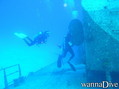
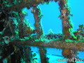
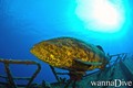
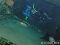
English (vertaal deze tekst in Nederlands): The MV Captain Keith Tibbetts was sunk in 1996 as an artificial reef. Since then, coral has grown nicely on the wreck. The wreck has since had its back broken by a Winter Nor'Wester storm which has resulted in a nice debris field amidships. It remains an interesting wreck with plenty to see on the outside, plus there's a couple of well-known and reasonably safe penetration opportunities. Fish life is present and is typical for the region, with local DMs often aware of where a resident Scorpionfish or two are residing.
The area off the bow of the ship leads out into a deeper sandflat area, and then coral formations at the wall dropoff. This area is not frequented by most divers who come to this mooring, partly because it isn't the wreck proper, but also because the dropoff starts deep, in approximately 110fsw. As with any bluewater dropoff, pelagics can occasionally be spotted in this area.
The MV Captain Keith Tibbetts was sunk in 1996 as an artificial reef. Since then, coral has grown nicely on the wreck. The wreck has since had its back broken by a Winter Nor'Wester storm which has resulted in a nice debris field amidships. It remains an interesting wreck with plenty to see on the outside, plus there's a couple of well-known and reasonably safe penetration opportunities. Fish life is present and is typical for the region, with local DMs often aware of where a resident Scorpionfish or two are residing.
The area off the bow of the ship leads out into a deeper sandflat area, and then coral formations at the wall dropoff. This area is not frequented by most divers who come to this mooring, partly because it isn't the wreck proper, but also because the dropoff starts deep, in approximately 110fsw. As with any bluewater dropoff, pelagics can occasionally be spotted in this area.
English (vertaal deze tekst in Nederlands): The MV Captain Keith Tibbetts was sunk in 1996 as an artificial reef. Since then, coral has grown nicely on the wreck. The wreck has since had its back broken by a Winter Nor'Wester storm which has resulted in a nice debris field amidships. It remains an interesting wreck with plenty to see on the outside, plus there's a couple of well-known and reasonably safe penetration opportunities. Fish life is present and is typical for the region, with local DMs often aware of where a resident Scorpionfish or two are residing.
The area off the bow of the ship leads out into a deeper sandflat area, and then coral formations at the wall dropoff. This area is not frequented by most divers who come to this mooring, partly because it isn't the wreck proper, but also because the dropoff starts deep, in approximately 110fsw. As with any bluewater dropoff, pelagics can occasionally be spotted in this area.
 Comments
login om dit tool te gebruiken.
Nog geen account? Registreer eerst; it's free!
Alle tonen (0)...
Wees de eerste en becommentarieer dit land
Fouten, Feedback
Je kunt deze pagina gebruiken om fouten te herstellen of nieuwe info toe te voegen. Als je problemen hebt met deze pagina, Stuur ons feedback.
 MV Captain Keith Tibbetts