This is an interactive map! Use controls to pan and zoom this map.
Access
|
How? From shore
Distance Instant access
Easy to find? Easy to find
|
|
Dive site Characteristics
Average depth 20 m / 65.6 ft
Max depth 32 m / 105 ft
Current None
Visibility Good ( 10 - 30 m)
Quality
Dive site quality Great
Experience All divers
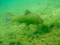
Bio interest Interesting
More details
Week crowd
Week-end crowd
Dive type
- Fresh water
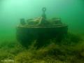
- Wreck
Dive site activities
- Children dive
- Night dive
- First dive
- Dive training
- Snorkeling / Free diving
- Orientation
- Photography
Dangers
Additional Information
English (Translate this text in English): Camp ground with cabins, trailor and tent sites. Exaltant set up with refills of Air and Nitrox at the waters edge. Entrance and exit of the lake is marked well. Sandy small rocks easy to walk on. exaltant to just walk in get set up and gradual slope to dive depth. dive plat form is 71 feet high coming with in 15 feet of the surface.
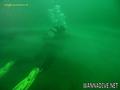
A plane is available near 20m deep.
English (Translate this text in English): Camp ground with cabins, trailor and tent sites. Exaltant set up with refills of Air and Nitrox at the waters edge. Entrance and exit of the lake is marked well. Sandy small rocks easy to walk on. exaltant to just walk in get set up and gradual slope to dive depth. dive plat form is 71 feet high coming with in 15 feet of the surface.
A plane is available near 20m deep.
Camp ground with cabins, trailor and tent sites. Exaltant set up with refills of Air and Nitrox at the waters edge. Entrance and exit of the lake is marked well. Sandy small rocks easy to walk on. exaltant to just walk in get set up and gradual slope to dive depth. dive plat form is 71 feet high coming with in 15 feet of the surface.
A plane is available near 20m deep.
English (Translate this text in English): Camp ground with cabins, trailor and tent sites. Exaltant set up with refills of Air and Nitrox at the waters edge. Entrance and exit of the lake is marked well. Sandy small rocks easy to walk on. exaltant to just walk in get set up and gradual slope to dive depth. dive plat form is 71 feet high coming with in 15 feet of the surface.
A plane is available near 20m deep.
 Comments
Please login to use this tool.
No account yet? Register first; it's free!
Show all (2)...
Errors, Feedback
You can edit this page to correct errors or add new information. If you have any problems regarding this page, Send us feedback.
Wannadive.net 24/24
Wannadive.net on your mobile

Newsletter All news by email
 Kulkwitzer See
By Wolfram Damies , 28-02-2009
Kulkwitzer See - Die Geschichte des Kulkwitzer Sees begann Anfang der sechziger Jahre des 19. Jahrhunderts, als der Landwirt Traugott Schröder Bohrungen durchführen ließ, wobei in etwa 20 m Tiefe 3-9 m mächtige Braunkohlenschichten festgestellt wurden. Kurze Zeit später begann der Kohleabbau in der Albersdorfer Flur zuerst unter Tage (1937 aus Rentabilitätsgründen aufgegeben) und dann im Tagebau bis nach Miltitz hin, was 1957 die Verlegung der F87 (B87) notwendig machte. Aus dem Abraum entstand die heute bewaldete Hochkippe; die Braunkohle wurde in das Kraftwerk Kulkwitz geliefert und dort verarbeitet (im Jahre 1960 lag die Förderung bei 2 Mio. Tonnen). Nach dem Ende der Auskohlung 1963 blieb in der Nähe von Miltitz ein Restloch zurück, das sich allmählich mit Grund- und Regenwasser füllte und dessen Erschließung und Nutzung als Naherholungsgebiet bereits fünf Jahre zuvor beschlossen wurde. Im Zuge der Rekultivierung wurden Bäume gepflanzt, Böschungen reguliert, Uferbereiche abgeflacht. Nach dem Umbau des 1972 herantransportierten ausgedienten Saalelastkahns "Frieda" (53m lang, 6m breit) entstand die Schiffsgaststätte "MS Leipzig" - heute das Chinarestaurant Dschunke. Die offizielle Eröffnung des Erholungsgebietes fand im Mai 1973 statt, und seit dem wird es ständig weiter ausgebaut. Am See standen Strandkörbe, Liegestühle und Ruderboote für die Erholungssuchenden zur Verfügung. Campingplatz und touristische Unterkünfte ergänzten das Angebot. Als Interessengemeinschaft Leipziger Betriebe entstand westlich von Lausen eine Bungalowsiedlung mit insgesamt 141 Sommerhäusern. In den 80er Jahren waren im Naherholungsgebiet neben Saisonkräften rund 80 Mitarbeiter angestellt.