This is an interactive map! Use controls to pan and zoom this map.
Access
|
Es pot aparcar pràcticament al costat, molt a prop de la residència d'estiu del president d'Islàndia, dins el Parc Nacional de Thingvellir.
English (Translate this text in English): Thingvellir National Park. Short walking distant to a ladder.
Thingvellir National Park. Short walking distant to a ladder.
English (Translate this text in English): Thingvellir National Park. Short walking distant to a ladder.
English (Translate this text in English): Thingvellir National Park. Short walking distant to a ladder.
English (Translate this text in English): Thingvellir National Park. Short walking distant to a ladder.
English (Translate this text in English): Thingvellir National Park. Short walking distant to a ladder.
English (Translate this text in English): Thingvellir National Park. Short walking distant to a ladder.
English (Translate this text in English): Thingvellir National Park. Short walking distant to a ladder.
How? From shore
Distance Short walk from shore (< 5min)
Easy to find? Easy to find
|
|
Dive site Characteristics
Average depth 26 m / 85.3 ft
Max depth 59 m / 193.6 ft
Current Low ( < 1 knot)
Visibility Excellent ( > 30 m)
Quality
Dive site quality Great
Experience CMAS ** / AOW
Bio interest Interesting
More details
Week crowd
Week-end crowd
Dive type
- Fresh water
- Cave
Dive site activities
- Night dive
- Dive training
- Snorkeling / Free diving
- Photography
Dangers
Additional Information
Es tracta d'una esquerda a la roca, situada al bell mig de la dorsal atlàntica, en el punt on les plaques europea i nord-americana se separen a raó de dos centímetres anuals. L'aigua és considerada la més transparent del món, amb una visibilitat superior a 150 metres, i prové d'una gelera relativament propera, encara que triga més de trenta anys a arribar-hi. És molt freda, entre 2 i 4ºC, però no es gela mai. Cal fer immersió amb vestit sec.
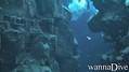
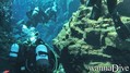
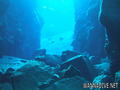
English (Translate this text in English): Imagine a large fissure filled up with icy, but crystal clear water, having a visibility of 50 meters and more, no suspended plankton, water just like the air around you. This is Silfra!
The sensational experience while diving in Silfra is just outstanding. The first part of the fissure is characterized by a deep cave leading under the road. The following part is divided by several deep ponds that are connected by tunnels in between the lava rocks. Even more impressive are the deep canyons that go down to 59 meters. From the bottom, the bubbles are searching their way up to the surface, disappearing in the intense blue filtered sunlight breaking the surface.
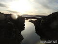
The landscape is marked geographically by a huge depression between two rifts running north-east. As the two main continental tectonic plates are drifting here apart (2 cm per year), the rift valley is constantly sinking. The result of this geological phenomenon is the lake Þingvallavatn - the largest natural lake in Iceland.
Imagine a large fissure filled up with icy, but crystal clear water, having a visibility of 50 meters and more, no suspended plankton, water just like the air around you. This is Silfra!
The sensational experience while diving in Silfra is just outstanding. The first part of the fissure is characterized by a deep cave leading under the road. The following part is divided by several deep ponds that are connected by tunnels in between the lava rocks. Even more impressive are the deep canyons that go down to 59 meters. From the bottom, the bubbles are searching their way up to the surface, disappearing in the intense blue filtered sunlight breaking the surface.
The landscape is marked geographically by a huge depression between two rifts running north-east. As the two main continental tectonic plates are drifting here apart (2 cm per year), the rift valley is constantly sinking. The result of this geological phenomenon is the lake Þingvallavatn - the largest natural lake in Iceland.
English (Translate this text in English): Imagine a large fissure filled up with icy, but crystal clear water, having a visibility of 50 meters and more, no suspended plankton, water just like the air around you. This is Silfra!
The sensational experience while diving in Silfra is just outstanding. The first part of the fissure is characterized by a deep cave leading under the road. The following part is divided by several deep ponds that are connected by tunnels in between the lava rocks. Even more impressive are the deep canyons that go down to 59 meters. From the bottom, the bubbles are searching their way up to the surface, disappearing in the intense blue filtered sunlight breaking the surface.
The landscape is marked geographically by a huge depression between two rifts running north-east. As the two main continental tectonic plates are drifting here apart (2 cm per year), the rift valley is constantly sinking. The result of this geological phenomenon is the lake Þingvallavatn - the largest natural lake in Iceland.
 Dive logs
Show all (5)...

|
By
Super dive - The best dive ever! Visit it if you ever get to iceland... You can by a trip to the site on dive.is
More... |
|
Comments
Please login to use this tool.
No account yet? Register first; it's free!
Show all (2)...
Errors, Feedback
You can edit this page to correct errors or add new information. If you have any problems regarding this page, Send us feedback.
 Silfra