This is an interactive map! Use controls to pan and zoom this map.
Access
|
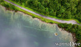
English (Translate this text in English): Access from route 655 from øye in too the mountain
English (Translate this text in English): Access from route 655 from øye in too the mountain
Access from route 655 from øye in too the mountain
English (Translate this text in English): Access from route 655 from øye in too the mountain
English (Translate this text in English): Access from route 655 from øye in too the mountain
English (Translate this text in English): Access from route 655 from øye in too the mountain
English (Translate this text in English): Access from route 655 from øye in too the mountain
English (Translate this text in English): Access from route 655 from øye in too the mountain
English (Translate this text in English): Access from route 655 from øye in too the mountain
How? From shore
Distance Instant access
Easy to find? Easy to find
|
|
Dive site Characteristics
Alternative name Civilizatione lost
Average depth 10 m / 32.8 ft
Max depth 18 m / 59.1 ft
Current None
Visibility Good ( 10 - 30 m)
Quality
Dive site quality Great
Experience CMAS * / OW
Bio interest None
More details
Week crowd
Week-end crowd
Dive type
- Fresh water
Dive site activities
- Night dive
- Snorkeling / Free diving
- Photography
- Handi-diving
Dangers
Additional Information
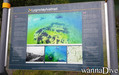
English (Translate this text in English): A small village that was flooded after a rock slide that blocked the river that flows down the valley and formed an artificial lake and flooded a farm that still stands as one can see today
The lake is at an altitude of ca 200 meter's above sea level
English (Translate this text in English): A small village that was flooded after a rock slide that blocked the river that flows down the valley and formed an artificial lake and flooded a farm that still stands as one can see today
The lake is at an altitude of ca 200 meter's above sea level
A small village that was flooded after a rock slide that blocked the river that flows down the valley and formed an artificial lake and flooded a farm that still stands as one can see today
The lake is at an altitude of ca 200 meter's above sea level
English (Translate this text in English): A small village that was flooded after a rock slide that blocked the river that flows down the valley and formed an artificial lake and flooded a farm that still stands as one can see today
The lake is at an altitude of ca 200 meter's above sea level
English (Translate this text in English): A small village that was flooded after a rock slide that blocked the river that flows down the valley and formed an artificial lake and flooded a farm that still stands as one can see today
The lake is at an altitude of ca 200 meter's above sea level
English (Translate this text in English): A small village that was flooded after a rock slide that blocked the river that flows down the valley and formed an artificial lake and flooded a farm that still stands as one can see today
The lake is at an altitude of ca 200 meter's above sea level
English (Translate this text in English): A small village that was flooded after a rock slide that blocked the river that flows down the valley and formed an artificial lake and flooded a farm that still stands as one can see today
The lake is at an altitude of ca 200 meter's above sea level
English (Translate this text in English): A small village that was flooded after a rock slide that blocked the river that flows down the valley and formed an artificial lake and flooded a farm that still stands as one can see today
The lake is at an altitude of ca 200 meter's above sea level
English (Translate this text in English): A small village that was flooded after a rock slide that blocked the river that flows down the valley and formed an artificial lake and flooded a farm that still stands as one can see today
The lake is at an altitude of ca 200 meter's above sea level
 Comments
Please login to use this tool.
No account yet? Register first; it's free!
Show all (0)...
Be the first to comment this country
Errors, Feedback
You can edit this page to correct errors or add new information. If you have any problems regarding this page, Send us feedback.
Wannadive.net 24/24
Wannadive.net on your mobile

Newsletter All news by email
 Lyngstølsvatnet