Utracono hasło? Nowy użytkownik? Zarejestruj się
Big eye, Philippines. Photo by Stephane Rochon.
Baw się i pomagaj!
| Znajdź najlepsze miejsce nurkowe |
|
|
 Pete Tide II
USA, Florida, Pensacola
Ta mapa jest interaktywna! Użyj kontrolek celem przybliżenia i oddalenia.
|
Data: WGS84 [ Pomocy ] |
Szerokość geograficzna: 30° 8.753' N |
Ocena użytkownika (0)
- Ulubione
-
Twoje ulubione i przyszłe miejsca nurkowe
Dostęp
|
English (Przetłumacz ten tekst w Polski): just northwest of the Heron & LCM Jak? Łodzią Odległość Długi czas na łodzi Łatwo znaleźć? Łatwe do znalezienia |
Charakterystyka miejsca nurkowego
Przeciętna głebokość 21 m / 68.9 ft
maksymalna głębokość 30.8 m / 101 ft
Prąd Powoli( < 1 knot)
Widoczność Dobry ( 10 - 30 m)
Jakość
Jakość miejsca nurkowania Dobry
Doświadczenie CMAS ** / AOW
Interesujący biologicznie Interesujący
Więcej informacji
Ilość nurków w tygodniu
Ilość nurków w week-end
Nurkowanie typu
- Wrak
Aktywności w miejscu
- Fotografia
Niebezpieczeństwa
- Głebokość
Dodatkowe informacje
Autor: gspooh37 Współpracownicy (3) Oni nurkowali w tym miejscu! (5)
 Zdjecia
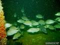
Pete Tide |

Pete Tide |
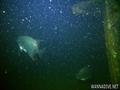
Pete Tide |
Pete Tide |
Dive logs
|
Komentarze
To będzie pierwszy komentarz o tym kraju
Błąd, powiadom nas o błędzie
możesz skorygować te błędy lub dodać informacje. Jeśli masz problemy odwiedź ta stronę, Wyślij nam odpowiedź zwrotną.