This is an interactive map! Use controls to pan and zoom this map.
Access
|
English (Translate this text in English): NOAA's Stellwagen Bank National Marine Sanctuary off Massachusetts
English (Translate this text in English): NOAA's Stellwagen Bank National Marine Sanctuary off Massachusetts
NOAA's Stellwagen Bank National Marine Sanctuary off Massachusetts
English (Translate this text in English): NOAA's Stellwagen Bank National Marine Sanctuary off Massachusetts
English (Translate this text in English): NOAA's Stellwagen Bank National Marine Sanctuary off Massachusetts
English (Translate this text in English): NOAA's Stellwagen Bank National Marine Sanctuary off Massachusetts
English (Translate this text in English): NOAA's Stellwagen Bank National Marine Sanctuary off Massachusetts
English (Translate this text in English): NOAA's Stellwagen Bank National Marine Sanctuary off Massachusetts
English (Translate this text in English): NOAA's Stellwagen Bank National Marine Sanctuary off Massachusetts
How? By boat
Distance Long boat time (> 30min)
Easy to find? Easy to find
|
|
Dive site Characteristics
Alternative name Unidentified Fishing Vessel
Average depth 32 m / 105 ft
Max depth 33.5 m / 109.9 ft
Current Medium ( 1-2 knots)
Visibility Excellent ( > 30 m)
Quality
Dive site quality Great
Experience CMAS ** / AOW
Bio interest Outstanding
More details
Week crowd
Week-end crowd
Dive type
- Wreck
- Big fishes
Dive site activities
- Marine biology
Dangers
- Depth
- Current
Additional Information
English (Translate this text in English): An unidentified trawler shipwreck rests on Stellwagen Bank in 105-110 feet of water in NOAA's Stellwagen Bank National Marine Sanctuary off Massachusetts. The trawler is broken into four pieces; its pilothouse, hull, stern, and net reel. Smaller hull fragments surround the site. As the shipwreck sits on a mostly featureless sand bottom, it attracts schools of cod and pollock that hide within its structure. The identity of this trawler has not been determined and the sanctuary is seeking help from anyone who might know its name. The trawler lies within the Outbound Lane of the Port of Boston’s Traffic Separation Scheme (TSS). Vessel operators should follow all regulations pertaining to the safe operation of vessels in a TSS.
The sanctuary offers SCUBA divers a chance to explore an offshore environment at the mouth of Massachusetts Bay. Exposed waters create challenging dive conditions, but offer rewarding experiences. Surprisingly, fifteen percent of the sanctuary, or 126 square miles, is shallower than 130 feet at low tide. Much of this area lies atop Stellwagen Bank, but also includes southern Jeffreys Ledge and the top of Sanctuary Hill. Diving offshore is unlike diving at a similar depth inshore. In addition to the deep water, you will likely experience strong currents at the surface and the bottom, especially if the wind and tide are moving in the same direction. Plan your dive around slack tide for the best underwater and surface conditions.
An unidentified trawler shipwreck rests on Stellwagen Bank in 105-110 feet of water in NOAA's Stellwagen Bank National Marine Sanctuary off Massachusetts. The trawler is broken into four pieces; its pilothouse, hull, stern, and net reel. Smaller hull fragments surround the site. As the shipwreck sits on a mostly featureless sand bottom, it attracts schools of cod and pollock that hide within its structure. The identity of this trawler has not been determined and the sanctuary is seeking help from anyone who might know its name. The trawler lies within the Outbound Lane of the Port of Boston’s Traffic Separation Scheme (TSS). Vessel operators should follow all regulations pertaining to the safe operation of vessels in a TSS.
The sanctuary offers SCUBA divers a chance to explore an offshore environment at the mouth of Massachusetts Bay. Exposed waters create challenging dive conditions, but offer rewarding experiences. Surprisingly, fifteen percent of the sanctuary, or 126 square miles, is shallower than 130 feet at low tide. Much of this area lies atop Stellwagen Bank, but also includes southern Jeffreys Ledge and the top of Sanctuary Hill. Diving offshore is unlike diving at a similar depth inshore. In addition to the deep water, you will likely experience strong currents at the surface and the bottom, especially if the wind and tide are moving in the same direction. Plan your dive around slack tide for the best underwater and surface conditions.
English (Translate this text in English): An unidentified trawler shipwreck rests on Stellwagen Bank in 105-110 feet of water in NOAA's Stellwagen Bank National Marine Sanctuary off Massachusetts. The trawler is broken into four pieces; its pilothouse, hull, stern, and net reel. Smaller hull fragments surround the site. As the shipwreck sits on a mostly featureless sand bottom, it attracts schools of cod and pollock that hide within its structure. The identity of this trawler has not been determined and the sanctuary is seeking help from anyone who might know its name. The trawler lies within the Outbound Lane of the Port of Boston’s Traffic Separation Scheme (TSS). Vessel operators should follow all regulations pertaining to the safe operation of vessels in a TSS.
The sanctuary offers SCUBA divers a chance to explore an offshore environment at the mouth of Massachusetts Bay. Exposed waters create challenging dive conditions, but offer rewarding experiences. Surprisingly, fifteen percent of the sanctuary, or 126 square miles, is shallower than 130 feet at low tide. Much of this area lies atop Stellwagen Bank, but also includes southern Jeffreys Ledge and the top of Sanctuary Hill. Diving offshore is unlike diving at a similar depth inshore. In addition to the deep water, you will likely experience strong currents at the surface and the bottom, especially if the wind and tide are moving in the same direction. Plan your dive around slack tide for the best underwater and surface conditions.
 Comments
Please login to use this tool.
No account yet? Register first; it's free!
Show all (1)...
Errors, Feedback
You can edit this page to correct errors or add new information. If you have any problems regarding this page, Send us feedback.
 Unidentified Trawler Shipwreck
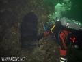

By Anonymous , 19-10-2010
WoW!!!!!!!!!!!!!!!!!! - WOW!!!!!!!!!!!!!!!!!!!!!!!!!!!!!!!!!!!!!!!!!!!!!!!!!!!!!!!!!!!!!!!!!!!!!!!!!!!!!!!!!!!!!!!!!!!!!!!!!!!!!!!!!!!!!!!!!!!!!!!!!!!!!!!!!!!!!!!no one has idinifided this